Military Education
by xdtxegvfbUnmanned vehicles
Here you can check your skill.
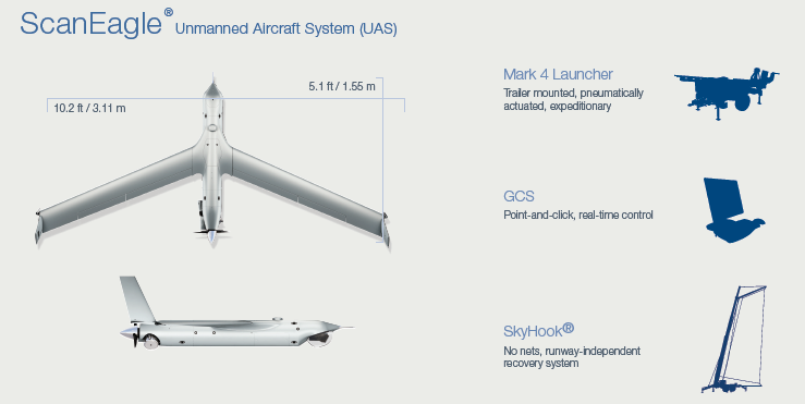
ScanEagle UAV Unmanned Aerial Vehicle

ScanEagle® unmanned aircraft system (UAS) is a low-cost solution with a small operational footprint that delivers high-quality imagery for intelligence, surveillance, and reconnaissance (ISR). ScanEagle, developed in partnership with Boeing, is currently in service with the U.S. Department of Defense, the Australian Defence Force, and other allied foreign militaries. Challenging weather conditions, unprepared terrain, and shipboard operations are easy with Insitu’s pneumatic catapult launcher and unique SkyHook® recovery system. Aircraft launch and recovery are performed safely and autonomously on land and at sea without a net or runway. In April 2004, ScanEagle made the first autonomous launch and recovery for fixed-wing UAVs aboard the 58-foot fishing boat, Shackleton. In July 2004, the U.S. Marine Corps awarded the Boeing/Insitu team a contract to provide two ScanEagle mobile deployment units. In August 2004, ScanEagle completed the longest flight ever recorded by a UAV launched and retrieved at sea -- 16 hours and 45 minutes.
Design
The UAV is based on Insitu's SeaScan miniature robotic aircraft and draws on Boeing's systems integration, communications and payload technologies. It carries either an electro-optical or an infrared camera. Both are inertially stabilized. The gimbaled camera allows the operator to easily track both stationary and moving targets. ScanEagle vehicles can operate individually or in groups to loiter over trouble spots.
Mobility
The ScanEagle is powered by a tail-mounted two-stroke gasoline-fueled off-the-shelf model aircraft engine. The ScanEagle, a joint development with Boeing, uses technology from combustion system specialist Sonex Research, to covert the UAV's 2.5hp (2kW) single-cylinder, two-stroke 3W-28 gasoline engine to burn jet fuel. The ScanEagle , which currently runs on automotive gasoline and which has demonstrated a maximum endurance of 22h, performed a flight of 28h 44min on 17 January at the company's facilities in Bingen, Washington.
Accessories
A standard ScanEagle unmanned aircraft (UA) carries a high-resolution electro-optic (EO) or infrared (IR) camera on a lightweight, inertially stabilized turret system. With communications range of over 55 nautical miles (100 km) and endurance of 24+ hours, the ScanEagle UAS is a versatile platform. Because the aircraft is completely modular, critical components can be swapped quickly in the field to ensure that ScanEagle is mission-ready.
Combat use
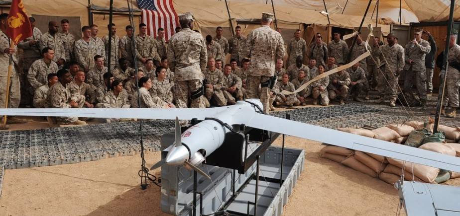
Because of its light weight and small system footprint, the ScanEagle UAS has low personnel requirements—only two operators are necessary. Insitu’s aircraft control software is user-friendly, and advanced automatic object-tracking technology greatly reduces operator workload. ScanEagle needs no airfield for deployment. Instead, it is launched using a pneumatic launcher designed as part of a university engineering design project, now patented by Insitu as the "SuperWedge" launcher. It is recovered using the "SkyHook" retrieval system, which uses a hook on the end of the wingtip to catch a rope hanging from a 4,5 to 15 m pole. This is made possible by a high-quality differential GPS units mounted on the top of the pole and UAV. The rope is attached to a shock cord to reduce stress on the airframe imposed by the abrupt stop. The four-foot-long ScanEagle system can provide more than 15 consecutive hours of "on-station" coverage and can operate in harsh weather environments, including high winds and heavy rains -- conditions that can keep other UAVs on the ground. The ScanEagle's internal avionics bay allows seamless integration of new payloads and sensors and ensures the vehicle will be able to incorporate the latest technology as it becomes available.
Dimensions
Length (EO dome): 5.1 ft / 1.55 m
Length (EO900/MWIR dome): 5.6 ft / 1.71 m
Wingspan: 10.2 ft / 3.11 m
Weights
Empty structure weight: 30.9-39.68 lb / 14-18 kg
Max takeoff weight: 48.5 lb / 22 kg
Max payload weight: 7.5 lb / 3.4 kg
Performance
Endurance: 24+ hours
Ceiling: 19,500 ft / 5,944 m
Service ceiling: 15,000 ft / 4,572 m
Max horizontal speed: 80 knots / 41.2 m/s
Cruise speed: 50-60 knots / 25.7-30.9 m/s
Engine: heavy fuel (JP-5 or JP-8) or gasoline engine
Payload Integration
On-board power: 60 W for payload
Sensor and Data Options
Turret: EO, EO900 (two EO imagers), MWIR, Dual imager (EO and MWIR)
Video datalink: Analog, digital encrypted
C2 datalink: Encrypted, unencrypted
OPTIONS
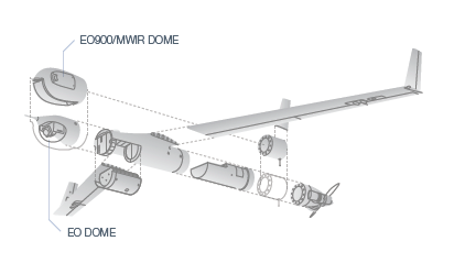
In the baseline configuration ScanEagle’s nose bay houses the Alticam Vision™ imaging system, a stabilized turret that eliminates in-flight vibrations and automatically tracks targets of interest. The turret incorporates the aircraft’s sensor package, which can be customized to include:
› Electro-optic imager: For high-resolution daytime imagery.
- 1.1°–25° field of view
- 36x continuous zoom
› EO900 turret: Picture-in-picture daytime imagery from two imagers, allowing operators to focus on and maintain positive identity for objects of interest.
- .3°–48.7° field of view
- 170x continuous zoom from one high-resolution imager
› MWIR camera: For quality thermal imaging for nighttime and low-visibility operations.
- 2°–25° field of view
-12.5x continuous zoom
› Dual Imager turret: Includes an EO and MWIR camera and laser marker for easy transition from daytime to nighttime missions.
MWIR:
-2°–25° field of view
-12.5x continuous zoom
EO:
- 1.1°–25° field of view
- 36x continuous zoom
RQ-4 Global Hawk

The RQ4 Global Hawk is a high-altitude, long-endurance unmanned aerial reconnaissance system designed to provide military field commanders with high-resolution, near real-time imagery of large geographic areas.
Sensors
The Global Hawk Sensor Suite is able to operate for more than 40 hours from an altitude of over 21,000 meters, day and night, in any weather. The SAR can operate simultaneously with either the EO or the IR sensor to enable coverage of wide geographic areas. This capability provides commanders with situational awareness, targeting, and bomb damage assessment. The EO sensor incorporates a third-generation IR sensor and a Kodak digital charge coupled device (CCD) visible wavelength camera. They provide image quality that enables users to distinguish types of vehicles, aircraft, and missiles. The sensor system makes it possible to distinguish types of vehicle, aircraft and missile and it can look through adverse weather, day or night. It can search a 40,000-square- nautical-mile area in 24 hours with three-foot resolution, or search 1,900-two-kilometre-square spots with one-foot resolution. The SAR has three imagery collection modes: a 0.3-meter resolution spot mode, a 1-meter resolution wide area search mode, and a 4-knot minimum detectable velocity moving target indicator (MTI) mode. The MTI mode provides the position and speed of moving targets. SAR imagery, which is processed on board the Global Hawk UAV, and EO/IR imagery are transmitted via data link in near real time, over satellite or line-of-light communication paths, to the MCE of the ground segment. The "bulge" at the top front surface of the fuselage which gives Global Hawk its distinctive appearance, houses the 48 inch Ku-band wideband satellite communications antenna.

Ground Stations
Global Hawk ground stations include the MCE and the LRE. The MCE is the Global Hawk's ground control station for reconnaissance operations. It contains four workstations: mission planning, sensor data and processing, air vehicle command and control operator (CCO), and communications. The LRE includes a mission planning function as well as air vehicle command and control. The complete MCE and the LRE is transportable in a single load on the C-5B transporter aircraft and in less than two loads on the C-17 transporter. A differential GPS system permits precision take-off and landing to an accuracy of approx. 30 cm. The Global Hawk's mission is to provide commanders in the field with near-real time high-resolution images. In April 2001, Global Hawk made aviation history when it completed the first non-stop flight across the Pacific Ocean by an unmanned, powered aircraft, flying from Edwards AFB, California, to the Royal Australian Air Force Base, Edinburgh, South Australia. Global Hawk successfully participated in a series of exercises with the RAAF, the Royal Australian Navy and the US Navy. Global Hawk can carry out reconnaissance missions in all types of operations. The 14,000 nautical mile range and 42 hour endurance of the air vehicle, combined with satellite and line-of-sight communication links to ground forces, permits world-wide operation of the system.
Versions
The first air vehicle in a new production lot of upgraded (Block 10) RQ-4A Global Hawk unmanned aerial reconnaissance vehicles made its maiden flight on July 1, 2004. Designated AF-3, the newest Global Hawk flew from Northrop Grumman Corporation's manufacturing facility in Palmdale, Calif., to the Flight Test Center at Edwards Air Force Base. "The first flight of AF-3 is a significant milestone for Global Hawk because it will be the first air vehicle from Lot 2 to be delivered to the Air Force with several combat-proven upgrades integrated into the system," said Carl O. Johnson, Northrop Grumman's Global Hawk vice president and integrated product team leader. AF-3 is part of Lot 2 of Global Hawk low-rate initial production and was delivered in July 2004. In June 2006 the last RQ-4 Block 10 version was delivered to the 452nd Flight Test Squadron at Edwards Air Force Base. The aircraft will undergo a series of acceptance and operational check flights before flying to Beale Air Force Base, Calif., to take its place as a fully operational reconnaissance aircraft. In August 2006, the Air Force announced the Global Hawk achieved 10,000 flight hours by late June, with a ratio of combat flying hours to non-combat hours increasing to 63 percent of total flight hours.